
Ice: a journey into the wintry heart of Canada's national parks
Experience this photo essay as a Google Earth Story, viewable using the Google Chrome browser. Mobile users will need the Google Earth app.
Ice is a landscape, a world, a way of life. It can be a quilt of light and froth pouring down a rock face; it can be a highway for animal and human travellers; it can be a decoration for beards and eyelashes.
Like gold or quartz, natural ice is a mineral. It is water that has been cooled to the point where "the molecules are brought within the play of the crystallizing force," in the words of the 19th-century geologist John Tyndall. Ice can be both art and archive: like rock, it inscribes the history of the environment in its layers.
But the empire of ice is shrinking as the earth warms. Explore ice in all its majesty and fragility in this tour of some frozen "hot spots" in Canada’s national parks.
Athabasca Glacier, Jasper National Park, Alberta
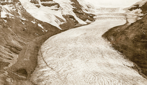
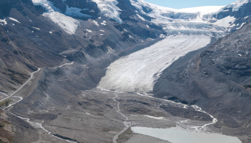
A glacier is made of snow that accumulates into a thick mass of ice.
Glaciers have been retreating throughout Canada's mountain parks for the past 50 years because of warming temperatures.
The two photos above show the Athabasca Glacier as it was in 1917 and then in 2011. (Images courtesy of the Mountain Legacy Project and Library and Archives Canada.)
The glacier now shrinks by about five metres per year and may be gone by 2100.
Dän Zhür (Donjek Glacier), Kluane National Park and Reserve, Yukon
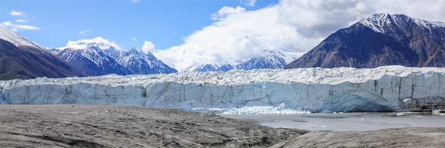
Surging glaciers are subject to sudden, rapid flows… rapid for a glacier, that is.
Yukon’s Kluane National Park and Reserve is home to the greatest concentration of surging glaciers in North America. The Dän Zhür (Donjek Glacier) is one of them. During its last surge, it advanced enough to partially dam the Donjek River, causing a lake to form behind the dam.
On July 13, 2019, the dam broke and the entire lake drained within a period of 36 hours. See images of this event (an example of "fast-frame geology") on our page about surging glaciers.
Like all of Kluane’s glaciers, Dän Zhür is losing ice mass each year due to rising temperatures from the combustion of fossil fuels. This has led to less extensive surge events and overall retreat of the glacier.
Wearable ice in Churchill, Manitoba
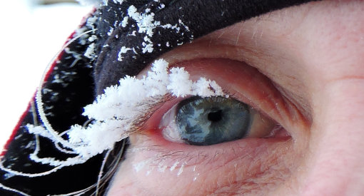
Frost consists of a layer of very small ice crystals that form when water vapour meets a freezing surface.
Parks Canada ecologist Chantal Ouimet got to wear some frost when she went for a walk around the town of Churchill, Manitoba. The temperature was -30 degrees Celsius, and the day was windless. As a result, the humidity from her eyes turned to frost without being blown away.
Churchill is the gateway to Wapusk National Park, which protects one of the largest known polar bear maternity denning areas in the world. And speaking of polar bears...
Emperor of the ice
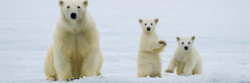
Every autumn, polar bears gather at Cape Churchill in Wapusk National Park, waiting for the sea ice to form. The bears depend on sea ice as a platform from which to hunt ringed seals, their main food.
Polar Bears International and explore.org have placed a webcam at Cape Churchill. Watch the emperor (and the imperial kids) in action!
Pond Inlet, Nunavut
Meet Brian Koonoo, a resource management officer for Parks Canada. Brian must often cross sea ice from the community of Pond Inlet to get to Sirmilik National Park.
Traditional knowledge has anciently guided travellers across the ice, but with climate change, such knowledge is becoming less and less reliable. So Brian depends on RADARSAT, a remote sensing Earth observation satellite program overseen by the Canadian Space Agency.
"RADARSAT really benefits those of us who live in northern communities," says Brian.
Pingos: body of earth, heart of ice
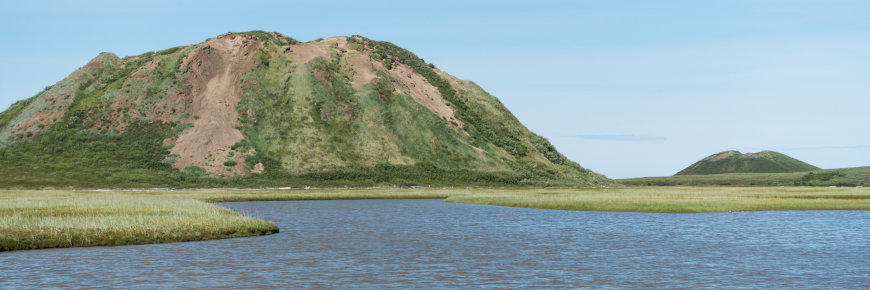
Pingo Canadian Landmark National Historic Site in the Northwest Territories protects a unique arctic landform: ice-cored hills called pingos.
Rising out of the flat tundra, these hills provide a distinctive backdrop to the community of Tuktoyaktuk, Northwest Territories. Pingo Canadian Landmark features eight of the 1350 pingos found in the region including Ibyuk Pingo, Canada's highest.
For centuries, pingos have acted as navigational aids for Inuvialuit (the people of the Western Arctic). They also offer a convenient height of land for spotting caribou on the tundra or whales offshore.
Of ice and snow
How are ice and snow related?
Snowflakes form when water vapour in the atmosphere turns directly into ice, bypassing the liquid stage. So snow basically consists of ice crystals that fall from the sky.
As the American palaeontologist Loren Eiseley put it, snow occurs when water "leaps out of vapour and thin nothingness... to array itself in form."
A must for students of snow is a visit to B.C.'s Glacier National Park. Mt. Fidelity in the park receives one of the highest average snowfall rates in Canada: 1388 centimetres (45.5 feet) per year.
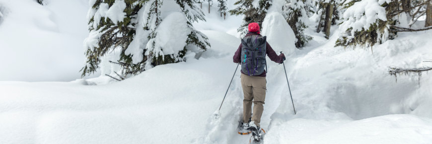
The snow walker at Banff National Park
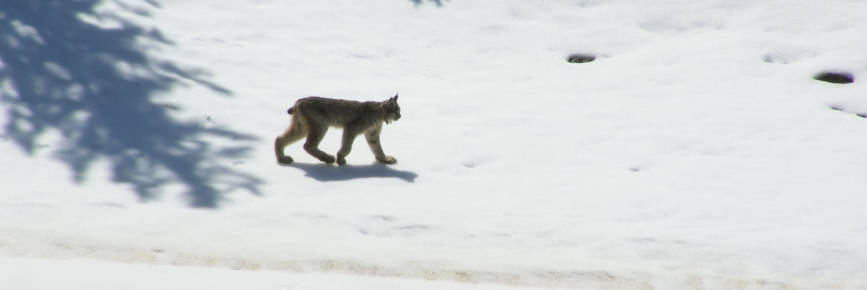
With their thick fur, long legs and large, furry “snowshoe” paws, lynx easily tolerate extreme cold and deep snows. They are seldom seen, however, being extremely wary of people.
But in 2013, Parks Canada's Alex Taylor filmed a mother lynx and her kitten near a section of the park's wildlife fencing along the Trans-Canada Highway. This highway fencing (together with wildlife overpasses and underpasses) has reduced wildlife-vehicle collisions by more than 80%.
Watch out for the clumpets and the lolly... and don’t let the dog go out on the cat ice!
The Dictionary of Prince Edward Island English, by T.K. Pratt, contains a wealth of words and phrases used by Islanders to describe different kinds of ice.
“Clumpets” are large chunks of floating sea ice. “Lolly” is soft, semi-congealed ice or floating snow. And “shell ice” is “a patch or layer of thin ice over thicker ice.” It’s also called “cat ice” because, of course, only a cat can walk on it.
The background image is of Dalvay Beach in Prince Edward Island National Park. The beach ecosystem actually depends on ice—specifically, on the presence of an “ice foot” (the pile of ice chunks which stack up on the beach in a continuous line). The ice foot shelters the dunes from storm driven wind and waves, and also protects the invertebrates living in the sand. Climate change could affect the length of time the ice foot is present.
- Date modified :