
Wilderness canoeing
Kejimkujik National Park and National Historic Site
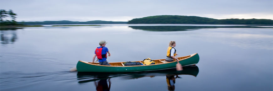
Canoeing is the best way to experience and explore the backcountry at Kejimkujik. You can enjoy the unfolding landscape as you travel from still waters to small lakes or across the island-studded expanse of Kejimkujik Lake.
Almost all canoeing is in flat water. No white-water canoeing is available in Kejimkujik except on some stretches of river in the spring, or during flood periods. Visit our canoeing section for more information on canoeing.
Due to varying water levels, clearly marked portages are provided around all fast water and between water systems. If you plan to travel more than a few kilometres by canoe you should be prepared to portage. Portage lengths vary from 150 metres to 2 kilometres.
- Canoe Routes
- Reservations and Registration
- Safety
- Portage Information
- Equipment Rental and Shuttle Service
- Planning Resources
Canoe routes
Big Dam/Frozen Ocean (26 km)
Starting Point: Take Portage Q (0.4 km) from the Big Dam Lake parking lot.
This is the best route for inexperienced canoeists, or the first time visitor who wants a two or three-day outing.
After years of experience, this route may well remain your favourite. Each lake is unique, but Big Dam Lake is the most striking. Joined in the middle by a narrow passage, it is really two water bodies in one. The southeast portion has clear water fed by springs and runoff, while the northwest portion is filled with dark red-brown water borne by a large brook, which flows through a bog. All along the route you’ll notice the tips of old logs floating just above the surface. Sphagnum moss, sundew and cranberries now grow on logs, which were lost while being driven downstream many years ago. The last logging drive was in the mid-1950s; the first was about a century ago.
While this trip can be done in two days, plan on taking three to enjoy it best. Spend a night on Frozen Ocean Lake and then one on Kejimkujik Lake. If you start late, stay at Big Dam Lake the first night and at Frozen Ocean the next.
Note: Except for Kejimkujik Lake, the lakes are generally small and are usually not too windy during the day. The stillwaters and the flowing part of the river are easy canoeing. The seven portages are of short to moderate length (130m to 800m) and, on a multi-day trip, the going is easy.
Kejimkujik Lake (8 km x 5 km)
Starting Point: Begin and end at Jakes Landing, or at the Eel Weir below Kejimkujik Lake at George Lake.
The shoreline and islands of Kejimkujik Lake, and the rivers leading into it, can be explored without portaging.
The mood of the big lake changes constantly — from misty mornings through bright, windy afternoons, to peaceful sunsets.
The islands vary from tiny sand spits to large forested islands, each with its own personality. Some have small hidden beaches; others may harbour a doe and her fawn. The rivers leading from the lake are excellent for viewing beaver and deer; the open lake is good for spotting loons, gulls, terns, and the occasional osprey.
Peskowesk Lake System (48 km)
Starting Point: Cross Kejimkujik Lake from Jakes Landing, or start from the Eel Weir below George Lake. Travel from Minards Bay to take the Big Hardwood Carry (Portage E), or Portage A.
Here, you will experience wilderness canoeing at its best. Fewer people travel this route because longer portages are necessary than in other areas. Many old-timers favour this part of Keji, whose landscape of windswept stands of red and white pine is reminiscent of the Canadian Shield. This system of a dozen lakes is connected by thirteen portages.
Some of the lakes are spring-fed and clear, others are fed by dark brown streams flowing through bogs. As their name implies, the Silver Lakes are among the clearest in the region. As you paddle, you can see the rocks and plants, metres below on the bottom.
Note: You should be well prepared to portage, and anticipate stiff westerly winds on both Peskowesk and Peskawa lakes in mid-day. Morning travel is advised.
Reservations and registration
When you arrive at Keji, you must register for backcountry camping at the Visitor Centre and return your permit at the end of your trip. Reservations are recommended.
One of the points of access to the Tobeatic Wilderness Area is through Pebbleloggitch Lake in Kejimkujik to the Shelburne River. This is a gateway to a world of wilderness adventure. If you plan to camp in Kejimkujik on your way into the Tobeatic or on your way back out you must register and pay the park camping fees.
Safety
Paddlers may encounter high winds and waves, and should have navigational and canoe camping skills. Foul weather may force you to stay put until conditions permit safe travel. Ensure your trip plan allows for extra time and provisions in case this happens to you.
Portages, marked with clear signs, are provided around all areas that are hazardous during high-water periods, or impassable when water levels are low. You will have to carry your canoe at all portages.
Transport Canada regulations require that you have a personal flotation device (PFD) for each person. These should be worn at all times.
You must have a bailer, 15 m buoyant heaving line, and a noisemaking device for attracting attention if you require help. Each canoe must have two paddles and one extra is suggested.
Portage information
All portages are well maintained and identified. Longer portages have canoe rests, and where appropriate, many portages have docks. Most portages are sufficiently smooth and suitable for pulling kayak/canoe portage wheels.
| Portage | Distance | Description |
|---|---|---|
| A | 1.2 km | Dry, rolling terrain, canoe rest provided. |
| B | 0.12 km | Over low ridge. Crosses the Fire Tower Road. |
| C | 0.4 km | Over a gradual rise. Short, steep section at the Cobrielle Lake end. |
| D | 0.64 km | Dry, rolling terrain. Canoe rest provided. |
| E | 2.3 km | Big Hardwood Carry, steep climb from Minards Bay to the Fire Tower Road. Canoe rests provided. |
| F | 0.62 km | Over rolling terrain. Canoe rest provided. |
| G | 0.8 km | Peskowesk end of this carry is hidden in a cove. Canoe rests provided. |
| H | 0.2 km | Over low ridge. |
| I | 0.2 km | Over low ridge. |
| J | 1.2 km | Follows the Liberty Lake Trail for some distance. Canoe rests provided. |
| K | 0.4 km | Steep climb from Peskowesk Lake. |
| L | 0.4 km | Fairly level terrain. |
| M | 0.2 km | Over low ridge. Canoe rest provided. This portage provides access via Pebbleloggitch Lake to the Shelburne River. |
| N | 0.8 km | Two separate carries, one short carry around bridge, the other longer over gently sloping terrain, rocky. Canoe rest provided. |
| O | 0.8 km | Gently sloping terrain. Excellent walking. Canoe rest provided. |
| P | 0.2 km | Gently sloping terrain. |
| Q | 0.4 km | Big Dam Lake access. Level terrain. Excellent walking. |
| R | 0.8 km | Gently sloping terrain. Excellent walking. Canoe rest provided. |
| S | 0.16 km | Level, rocky terrain. |
| T | 0.13 km | Level terrain. |
| U | 0.33 km | Level terrain. Most of the portage is boardwalk. |
| V | 0.7 km | Gently sloping terrain. Excellent walking. Canoe rest provided. |
| W | 0.45 km | Level terrain. Excellent walking. Canoeists may wish to use this carry to avoid high winds on Kejimkujik Lake. |
Equipment rentals and shuttle service
Canoes, kayaks, and the safety equipment required to use them are available for rent in Kejimkujik from Whynot Adventure, The Keji Outfitters. If your trip does not begin and end at the same location you can contact the outfitter to make reservations for their shuttle service to drop you off or pick you up.
Planning resources
The Backcountry Guide is available by calling the Kejimkujik’s Visitor Centre, Whynot Adventure, The Keji Outfitters, Mountain Equipment Co-op (Halifax), or The Trail Shop (Halifax).
Keji: A Guide to Kejimkujik National Park and National Historic Site, produced by the Friends of Keji, is available at By The Mersey Gift Shop in the Visitor Centre, and at select bookshops.
Paddling the Tobeatic, by Andrew L. Smith
Paddle Lunenburg-Queens, by Sheena Masson
Paddle Annapolis County, by the Annapolis County Department of Recreation
Related links
- Date modified :