

Shorty Creek Trail
Kluane National Park and Reserve
Distance: 24 km (15 mi) return trip
Time: 6-9 hrs
Elevation gain: 275 m (900')
Maximum elevation: 1,007 m (3,300')
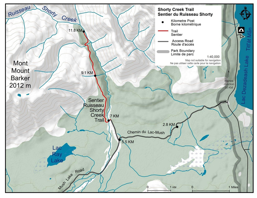
Trailhead: 54 km (33.5 mi) south of Haines Junction on the Haines Highway, turn into Mush Lake Road.
Topo map: Mush Lake 115 A/6
In summary
This trail begins 54 km south of Haines Junction. The first 5.5 km of the trail is on the 4 wheel drive road that leads to Mush Lake. The hike is fairly steep but quite easy as it follows an old mining road for most of the distance. There are good opportunities to see wildlife and examples of the mining equipment that was used to extract the gold from the creek that 'Long Shorty' Bigelow first mined in 1896.
UPDATE: The suspension bridge has been washed away, as of June 2023.
The details
From the Haines Highway, the Mush Lake Road crosses one small creek 1 km in. The road then forks at the 2.8 km post. The left branch rejoins the right after a short distance that bypasses a winding hill, it is preferable to follow the left branch. The next fork occurs at kilometer post 5.5; as indicated, follow the right branch 1km to Alder Creek, where there is room to park and turn around.
Depending on water levels, you may need to go off trail and bush whack to find a good place to cross the creek.
After crossing Shorty Creek, the trail can be found continuing past the gate on the far side. The first 2 km are steady uphill and then the trail levels off in the sub alpine. While climbing, Ray Lake becomes visible down the valley to the west. The shoreline of this lake is ideal for feeding moose, and binoculars may help to spot one. Once in the sub alpine, the old mining road contours along the side of a ridge off Mt. Barker. For energetic route finders, this ridge appears to offer a reasonably accessible route to the top of Mt. Barker.
After a kilometer through the sub alpine the road slopes down to Alder Creek, crossing a small creek in the process. The road continues along Alder Creek through some green meadows. This region has many signs of bear activity, including three or four good bear stomps. Past the meadows the trail narrows for the remaining 400 m to Shorty Creek, which runs into Alder Creek from the west.
On Shorty Creek there are many remnants of the mining operations that have searched for gold on this creek. Within 1 km of Alder Creek there is the remains of a sluice box, a spoke wheel horse drawn wagon, Caterpillar track, tailing piles and many other artifacts and ironworks. Some of these artifacts may be difficult to find in the dense alders and willows growing along the creek. Please remember to take only photos and leave only footprints so other people can explore and enjoy the area.
The trail ends here but there are many possible off-trail routes that can be taken: continue north along Alder Creek and explore the alpine lakes at its headwaters (another 6 km up); continue northwest up the ridge between Shorty and Alder Creeks for a view of both creek valleys; head west along Shorty Creek and to points in the alpine above the creek (two big alpine plateaus); or head southwest on the ridge ascending Mt. Barker.
What you need to know
Camping is not recommended along the Shorty Creek Trail. There are better areas for camping approximately 4 km further up, beyond the end of the trail. Stay on the south side of Shorty Creek to approximately UTM LB 780 990 (the creek branches here). Continue across the tributary, staying on the south side of Shorty Creek, then through a canyon-like area to an open area good for camping. Please practice low impact/no trace camping.
For all overnight trips in the park Approved Bear Resistant Food Canisters are mandatory and a Wilderness Permit is required. Both can be obtained from the Kluane National Park and Reserve Visitor Centre in Haines Junction. For more information: Overnight registration.
Bear sightings are common in this area. Review recommendations for travel within the You Are In Bear Country brochure. Please report all bear sightings to the staff at the Visitor Centre.
Parks Canada 24 hour emergency dispatch
1-780-852-3100
Cellular telephones do not work in most of the park. Satellite phones or satellite messaging devices are strongly recommended.
Related links
- Date modified :